 Note:
The expiration time in the watch graphic is amended if the watch is
replaced, cancelled or extended.
Note:
Note:
The expiration time in the watch graphic is amended if the watch is
replaced, cancelled or extended.
Note: Click for
Watch Status Reports.
SEL6
URGENT - IMMEDIATE BROADCAST REQUESTED
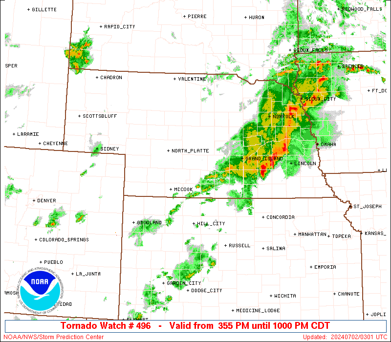
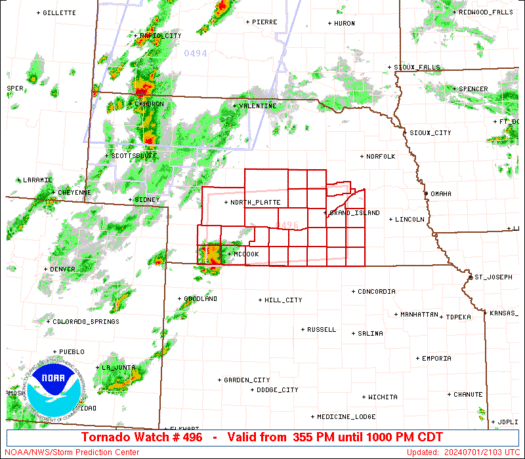
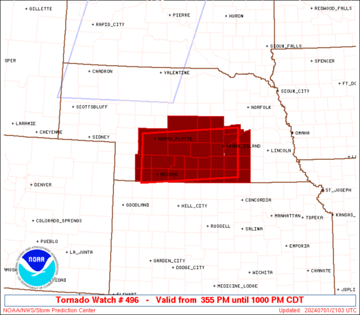
Tornado Watch Number 496
NWS Storm Prediction Center Norman OK
355 PM CDT Mon Jul 1 2024
The NWS Storm Prediction Center has issued a
* Tornado Watch for portions of
Southern and Central Nebraska
* Effective this Monday afternoon and evening from 355 PM until
1000 PM CDT.
* Primary threats include...
A couple tornadoes possible
Scattered damaging winds likely with isolated significant gusts
to 75 mph possible
Scattered large hail and isolated very large hail events to 2
inches in diameter possible
SUMMARY...Thunderstorms should move east-northeastward along and
near a warm front that will become draped across south-central
Nebraska this afternoon and evening. A couple of tornadoes may occur
with any sustained supercell, along with large hail around 1-2
inches in diameter. Severe/damaging winds may become an increasing
concern if thunderstorms can grow into a small cluster later this
evening.
The tornado watch area is approximately along and 45 statute miles
north and south of a line from 40 miles northwest of Mccook NE to 30
miles east southeast of Grand Island NE. For a complete depiction of
the watch see the associated watch outline update (WOUS64 KWNS
WOU6).
PRECAUTIONARY/PREPAREDNESS ACTIONS...
REMEMBER...A Tornado Watch means conditions are favorable for
tornadoes and severe thunderstorms in and close to the watch
area. Persons in these areas should be on the lookout for
threatening weather conditions and listen for later statements
and possible warnings.
&&
OTHER WATCH INFORMATION...CONTINUE...WW 494...WW 495...
AVIATION...Tornadoes and a few severe thunderstorms with hail
surface and aloft to 2 inches. Extreme turbulence and surface wind
gusts to 65 knots. A few cumulonimbi with maximum tops to 500. Mean
storm motion vector 26035.
...Gleason

   SEL6

   URGENT - IMMEDIATE BROADCAST REQUESTED
   Tornado Watch Number 496
   NWS Storm Prediction Center Norman OK
   355 PM CDT Mon Jul 1 2024

   The NWS Storm Prediction Center has issued a

   * Tornado Watch for portions of
     Southern and Central Nebraska

   * Effective this Monday afternoon and evening from 355 PM until
     1000 PM CDT.

   * Primary threats include...
     A couple tornadoes possible
     Scattered damaging winds likely with isolated significant gusts
       to 75 mph possible
     Scattered large hail and isolated very large hail events to 2
       inches in diameter possible

   SUMMARY...Thunderstorms should move east-northeastward along and
   near a warm front that will become draped across south-central
   Nebraska this afternoon and evening. A couple of tornadoes may occur
   with any sustained supercell, along with large hail around 1-2
   inches in diameter. Severe/damaging winds may become an increasing
   concern if thunderstorms can grow into a small cluster later this
   evening.

   The tornado watch area is approximately along and 45 statute miles
   north and south of a line from 40 miles northwest of Mccook NE to 30
   miles east southeast of Grand Island NE. For a complete depiction of
   the watch see the associated watch outline update (WOUS64 KWNS
   WOU6).

   PRECAUTIONARY/PREPAREDNESS ACTIONS...

   REMEMBER...A Tornado Watch means conditions are favorable for
   tornadoes and severe thunderstorms in and close to the watch
   area. Persons in these areas should be on the lookout for
   threatening weather conditions and listen for later statements
   and possible warnings.

   &&

   OTHER WATCH INFORMATION...CONTINUE...WW 494...WW 495...

   AVIATION...Tornadoes and a few severe thunderstorms with hail
   surface and aloft to 2 inches. Extreme turbulence and surface wind
   gusts to 65 knots. A few cumulonimbi with maximum tops to 500. Mean
   storm motion vector 26035.

   ...Gleason
 Note:
The Aviation Watch (SAW) product is an approximation to the watch area.
The actual watch is depicted by the shaded areas.
Note:
The Aviation Watch (SAW) product is an approximation to the watch area.
The actual watch is depicted by the shaded areas.
   SAW6
   WW 496 TORNADO NE 012055Z - 020300Z
   AXIS..45 STATUTE MILES NORTH AND SOUTH OF LINE..
   40NW MCK/MCCOOK NE/ - 30ESE GRI/GRAND ISLAND NE/
   ..AVIATION COORDS.. 40NM N/S /34NW MCK - 43SE OBH/
   HAIL SURFACE AND ALOFT..2 INCHES. WIND GUSTS..65 KNOTS.
   MAX TOPS TO 500. MEAN STORM MOTION VECTOR 26035.

   LAT...LON 41260112 41459779 40159779 39960112

   THIS IS AN APPROXIMATION TO THE WATCH AREA.  FOR A
   COMPLETE DEPICTION OF THE WATCH SEE WOUS64 KWNS
   FOR WOU6.
Watch 496 Status Report Messages:
STATUS REPORT #4 ON WW 496
VALID 020200Z - 020300Z
SEVERE WEATHER THREAT CONTINUES RIGHT OF A LINE FROM 45 SSW HSI
TO 10 SSE GRI TO 25 SW OFK.
WW 496 WILL BE ALLOWED TO EXPIRE AT 020300Z.
..SQUITIERI..07/02/24
ATTN...WFO...GID...LBF...GLD...
&&
STATUS REPORT FOR WT 496
SEVERE WEATHER THREAT CONTINUES FOR THE FOLLOWING AREAS
NEC035-059-081-121-125-129-143-169-185-020300-
NE
. NEBRASKA COUNTIES INCLUDED ARE
CLAY FILLMORE HAMILTON
MERRICK NANCE NUCKOLLS
POLK THAYER YORK
$$
THE WATCH STATUS MESSAGE IS FOR GUIDANCE PURPOSES ONLY. PLEASE
REFER TO WATCH COUNTY NOTIFICATION STATEMENTS FOR OFFICIAL
INFORMATION ON COUNTIES...INDEPENDENT CITIES AND MARINE ZONES
CLEARED FROM SEVERE THUNDERSTORM AND TORNADO WATCHES.
$$
STATUS REPORT #3 ON WW 496
VALID 020045Z - 020140Z
SEVERE WEATHER THREAT CONTINUES RIGHT OF A LINE FROM 25 NNE HLC
TO 45 ENE MCK TO 30 E BUB.
..WEINMAN..07/02/24
ATTN...WFO...GID...LBF...GLD...
&&
STATUS REPORT FOR WT 496
SEVERE WEATHER THREAT CONTINUES FOR THE FOLLOWING AREAS
NEC001-019-035-059-061-073-077-079-081-083-093-099-121-125-129-
137-143-163-169-175-181-185-020140-
NE
. NEBRASKA COUNTIES INCLUDED ARE
ADAMS BUFFALO CLAY
FILLMORE FRANKLIN GOSPER
GREELEY HALL HAMILTON
HARLAN HOWARD KEARNEY
MERRICK NANCE NUCKOLLS
PHELPS POLK SHERMAN
THAYER VALLEY WEBSTER
YORK
$$
THE WATCH STATUS MESSAGE IS FOR GUIDANCE PURPOSES ONLY. PLEASE
REFER TO WATCH COUNTY NOTIFICATION STATEMENTS FOR OFFICIAL
INFORMATION ON COUNTIES...INDEPENDENT CITIES AND MARINE ZONES
CLEARED FROM SEVERE THUNDERSTORM AND TORNADO WATCHES.
$$
STATUS REPORT #2 ON WW 496
VALID 012355Z - 020040Z
SEVERE WEATHER THREAT CONTINUES RIGHT OF A LINE FROM 30 S MCK TO
10 ESE BUB.
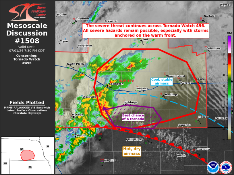
FOR ADDITIONAL INFORMATION SEE MESOSCALE DISCUSSION 1508
..WEINMAN..07/01/24
ATTN...WFO...GID...LBF...GLD...
&&
STATUS REPORT FOR WT 496
SEVERE WEATHER THREAT CONTINUES FOR THE FOLLOWING AREAS
NEC001-019-035-059-061-065-073-077-079-081-083-093-099-121-125-
129-137-143-163-169-175-181-185-020040-
NE
. NEBRASKA COUNTIES INCLUDED ARE
ADAMS BUFFALO CLAY
FILLMORE FRANKLIN FURNAS
GOSPER GREELEY HALL
HAMILTON HARLAN HOWARD
KEARNEY MERRICK NANCE
NUCKOLLS PHELPS POLK
SHERMAN THAYER VALLEY
WEBSTER YORK
$$
THE WATCH STATUS MESSAGE IS FOR GUIDANCE PURPOSES ONLY. PLEASE
REFER TO WATCH COUNTY NOTIFICATION STATEMENTS FOR OFFICIAL
INFORMATION ON COUNTIES...INDEPENDENT CITIES AND MARINE ZONES
CLEARED FROM SEVERE THUNDERSTORM AND TORNADO WATCHES.
$$
STATUS REPORT #1 ON WW 496
VALID 012240Z - 012340Z
SEVERE WEATHER THREAT CONTINUES RIGHT OF A LINE FROM 10 E IML TO
25 NW BBW.
..WEINMAN..07/01/24
ATTN...WFO...GID...LBF...GLD...
&&
STATUS REPORT FOR WT 496
SEVERE WEATHER THREAT CONTINUES FOR THE FOLLOWING AREAS
NEC001-019-035-041-047-059-061-063-065-073-077-079-081-083-085-
087-093-099-111-121-125-129-137-143-145-163-169-175-181-185-
012340-
NE
. NEBRASKA COUNTIES INCLUDED ARE
ADAMS BUFFALO CLAY
CUSTER DAWSON FILLMORE
FRANKLIN FRONTIER FURNAS
GOSPER GREELEY HALL
HAMILTON HARLAN HAYES
HITCHCOCK HOWARD KEARNEY
LINCOLN MERRICK NANCE
NUCKOLLS PHELPS POLK
RED WILLOW SHERMAN THAYER
VALLEY WEBSTER YORK
$$
THE WATCH STATUS MESSAGE IS FOR GUIDANCE PURPOSES ONLY. PLEASE
REFER TO WATCH COUNTY NOTIFICATION STATEMENTS FOR OFFICIAL
INFORMATION ON COUNTIES...INDEPENDENT CITIES AND MARINE ZONES
CLEARED FROM SEVERE THUNDERSTORM AND TORNADO WATCHES.
$$
Note:
Click for Complete Product Text.
Tornadoes
Probability of 2 or more tornadoes
|
Mod (40%)
|
Probability of 1 or more strong (EF2-EF5) tornadoes
|
Low (20%)
|
Wind
Probability of 10 or more severe wind events
|
Mod (60%)
|
Probability of 1 or more wind events > 65 knots
|
Mod (30%)
|
Hail
Probability of 10 or more severe hail events
|
Mod (50%)
|
Probability of 1 or more hailstones > 2 inches
|
Mod (30%)
|
Combined Severe Hail/Wind
Probability of 6 or more combined severe hail/wind events
|
High (80%)
|
For each watch, probabilities for particular events inside the watch
(listed above in each table) are determined by the issuing forecaster.
The "Low" category contains probability values ranging from less than 2%
to 20% (EF2-EF5 tornadoes), less than 5% to 20% (all other probabilities),
"Moderate" from 30% to 60%, and "High" from 70% to greater than 95%.
High values are bolded and lighter in color to provide awareness of
an increased threat for a particular event.


 @NWSSPC