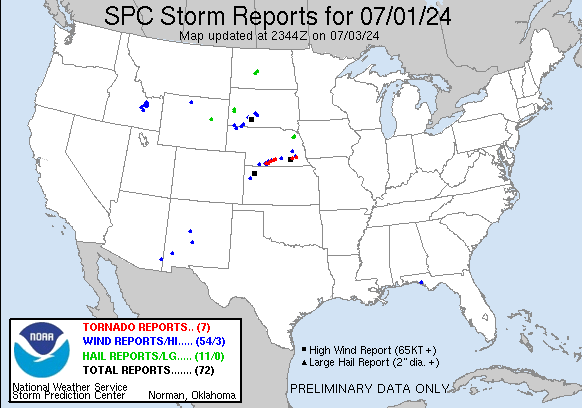
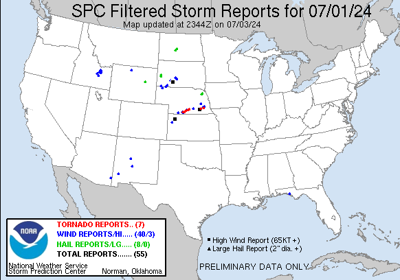
| Tornado Reports (CSV) (Raw Tornado CSV)(?) |
|---|
Time | | Location | County | State | Lat | Lon | Comments |
| 2251 | | 2 N Beaver City | Furnas | NE | 4017 | 9983 | Storm chaser reports brief touchdown of a rope tornado 2-3 miles north of Beaver City. (GID) |
| 2309 | | 2 SE Oxford | Harlan | NE | 4024 | 9961 | A tornado was on the ground temporarily ... dropping in and out with lots of rotation. (GID) |
| 2329 | | 1 NE Atlanta | Phelps | NE | 4038 | 9946 | Estimated location of trained spotter reporting a brief touchdown of a tornado. (GID) |
| 0008 | | 3 SSE Axtell | Kearney | NE | 4044 | 9911 | A brief Tornado. (GID) |
| 0024 | | 4 ENE Minden | Kearney | NE | 4053 | 9888 | Estimated location of rope tornado. (GID) |
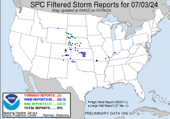
| Hail Reports (CSV) (Raw Hail CSV)(?) |
|---|
Time | Size | Location | County | State | Lat | Lon | Comments |
| 1900 | 100 | Tilford | Meade | SD | 4430 | 10343 | (UNR) |
| 1902 | 175 | Tilford | Meade | SD | 4430 | 10343 | 0.51 inch rain (UNR) |
| 1919 | 125 | 1 NNW Piedmont | Meade | SD | 4424 | 10340 | (UNR) |
| 1920 | 100 | 1 NNW Piedmont | Meade | SD | 4424 | 10340 | (UNR) |
| 2008 | 100 | 2 W Black Hawk | Meade | SD | 4415 | 10335 | (UNR) |
| 2145 | 125 | Center | Oliver | ND | 4712 | 10130 | Relayed report through broadcast media including photo. (BIS) |
| 2200 | 100 | Washburn | McLean | ND | 4729 | 10103 | Report relayed by broadcast media. (BIS) |
| 0030 | 100 | 25 WNW Bill | Converse | WY | 4335 | 10572 | (CYS) |
| 0125 | 100 | Wayne | Wayne | NE | 4223 | 9701 | (OAX) |
| 0129 | 100 | 6 W Wakefield | Dixon | NE | 4228 | 9698 | (FSD) |
| 0132 | 100 | Wayne | Wayne | NE | 4223 | 9702 | (OAX) |
| Wind Reports (CSV) (Raw Wind CSV)(?) |
|---|
Time | Speed | Location | County | State | Lat | Lon | Comments |
| 1651 | UNK | 5 N Martell | Lancaster | NE | 4071 | 9674 | Roof ripped off a farm building ... extensive tree damage ... and silo destroyed. Potential tornado damage. Time estimated from radar. (OAX) |
| 2030 | 60 | 11 S Oelrichs | Fall River | SD | 4302 | 10323 | (UNR) |
| 2035 | 59 | 3 W Belen | Valencia | NM | 3465 | 10683 | AWOS station KBRG Belen Regional Airport. (ABQ) |
| 2038 | 59 | 2 NW Greybull | Big Horn | WY | 4452 | 10808 | ASOS station KGEY Greybull Airport. (RIW) |
| 2047 | 71 | 5 W Chadron | Dawes | NE | 4283 | 10310 | ASOS station KCDR Chadron Airport - Cdr. (CYS) |
| 2105 | 60 | 1 SE Silver City | Grant | NM | 3277 | 10825 | Spotter reported a measure 60 mph wind gust with lots of pea size and around 0.50 inches of rain in the last hour. (EPZ) |
| 2113 | 60 | 2 W Pine Ridge | Oglala Lakota | SD | 4303 | 10259 | (UNR) |
| 2123 | 64 | 3 ESE Pine Ridge | Oglala Lakota | SD | 4303 | 10252 | (UNR) |
| 2143 | 60 | 8 SE Mccook | Red Willow | NE | 4012 | 10052 | Spotter report of 50-60 MPH winds and heavy rain reducing visibility down to 0.25 mile. (GLD) |
| 2145 | 60 | 3 NE Wounded Knee | Oglala Lakota | SD | 4318 | 10232 | (UNR) |
| 2151 | 66 | 6 NE West Bay | Bay | FL | 3036 | 8580 | (TAE) |
| 2155 | 58 | 6 NE West Bay | Bay | FL | 3036 | 8580 | (TAE) |
| 2230 | 60 | 7 E Wanblee | Jackson | SD | 4358 | 10152 | (UNR) |
| 2231 | 86 | Colby | Thomas | KS | 3939 | 10105 | Delayed report of EM weather station recording a 86 MPH gust. Damage was also reported around Colby. (GLD) |
| 2231 | UNK | Colby | Thomas | KS | 3939 | 10105 | Delayed report from EM of structural damage to a shed ... windows blown out of trucks ... and tree limbs blown down. (GLD) |
| 2232 | 58 | 6 SSE Holbrook | Furnas | NE | 4022 | 9997 | (GID) |
| 2233 | 61 | 2 W Colby | Thomas | KS | 3939 | 10109 | KS Mesonet site reported 61 MPH gust. (GLD) |
| 2234 | 64 | 1 NE Colby | Thomas | KS | 3940 | 10103 | Ambient Weather station Ostmeyer in eastern Colby reported 64 MPH Gust. (GLD) |
| 2235 | 58 | 6 SSE Holbrook | Furnas | NE | 4022 | 9997 | Corrects time of previous tstm wnd gst report from 6 SSE Holbrook. (GID) |
| 2235 | 78 | 7 E Wanblee | Jackson | SD | 4358 | 10152 | (UNR) |
| 2240 | 62 | 33 SSW Duncan | Cochise | AZ | 3226 | 10922 | Trained Spotter reported a thunderstorm wind gust of 62 mph from weather station in San Simon. Heavy rain is also reported. (TWC) |
| 2241 | 60 | 8 E Interior | Jackson | SD | 4373 | 10182 | (UNR) |
| 2243 | 66 | 34 SSW Duncan | Cochise | AZ | 3226 | 10923 | (TWC) |
| 2245 | 58 | 9 WSW Winona | Logan | KS | 3900 | 10139 | Mesonet station UP840 9.0 W Winona (UPR) with nearby AWN Mesonet reporting 54 MPH. (GLD) |
| 2245 | 65 | 7 E Wanblee | Jackson | SD | 4358 | 10152 | (UNR) |
| 2256 | 61 | 10 SW Bingham | Socorro | NM | 3379 | 10649 | Mesonet station WSM40 Mine (WSMR). (ABQ) |
| 2256 | 68 | 1 NE Midland | Haakon | SD | 4408 | 10114 | (UNR) |
| 2315 | 69 | Okaton | Jones | SD | 4388 | 10089 | (ABR) |
| 2325 | 58 | 12 E Howe | Butte | ID | 4378 | 11276 | Mesonet station SAN Sand Dunes. (PIH) |
| 2330 | 61 | 6 WNW Atlanta | Phelps | NE | 4039 | 9958 | (GID) |
| 2338 | UNK | 1 SE Holdrege | Phelps | NE | 4043 | 9936 | Social media report of 1-2 inch in diameter branches down south of the fairgrounds. Time estimated based on radar. (GID) |
| 2339 | 66 | 3 SSW Holdrege | Phelps | NE | 4039 | 9940 | From WL-HOLDREGE3.44SSW. (GID) |
| 2340 | 60 | 1 SSE Arco | Butte | ID | 4362 | 11330 | Mesonet station ARC 1 SSE Arco. (PIH) |
| 2345 | 60 | 1 ENE Howe | Butte | ID | 4378 | 11298 | Mesonet station HOW 1 ENE Howe. (PIH) |
| 2345 | 60 | 18 NNE Berenice | Clark | ID | 4407 | 11284 | Mesonet station BLU Blue Dome. (PIH) |
| 2355 | 60 | 3 ENE Holdrege | Phelps | NE | 4045 | 9932 | AWOS station KHDE Holdrege Airport. (GID) |
| 2357 | 66 | 2 SW Axtell | Kearney | NE | 4047 | 9915 | (GID) |
| 2358 | UNK | Axtell | Kearney | NE | 4048 | 9913 | Public report via social media of a fence down in Axtell and damage to a home. Time estimated based on radar. (GID) |
| 0000 | 61 | 13 WNW Monteview | Clark | ID | 4403 | 11275 | Mesonet station PC374 Reno Gulch. (PIH) |
| 0003 | UNK | Axtell | Kearney | NE | 4048 | 9913 | Tree branches down on the highway in Axtell via storm chaser. (GID) |
| 0005 | UNK | Axtell | Kearney | NE | 4048 | 9912 | Several branches down across the yard (3-6 inch diameter) Social media image. (GID) |
| 0012 | UNK | Minden | Kearney | NE | 4050 | 9895 | 6 inch tree limbs reported broken in the city of Minden. Time estimated from radar. (GID) |
| 0015 | 59 | 11 WSW Monteview | Butte | ID | 4386 | 11273 | Mesonet station LOF INL Specific Manufacturing. (PIH) |
| 0023 | UNK | Axtell | Kearney | NE | 4048 | 9913 | A tree was split in half & tree fell on neighbors garage in East Axtell. (GID) |
| 0030 | 70 | 11 WSW Atomic City | Butte | ID | 4340 | 11302 | Mesonet station SUM Big Southern Butte. (PIH) |
| 0040 | UNK | Minden | Kearney | NE | 4050 | 9895 | Delayed report. Via MPING Shingles blown off and one inch tree limbs broken. (GID) |
| 0148 | 59 | 4 ESE Hastings | Adams | NE | 4058 | 9832 | (GID) |
| 0245 | UNK | 3 SW Garrison | Butler | NE | 4113 | 9720 | Report from mPING: 1-inch tree limbs broken; Shingles blown off. (OAX) |
| 0323 | 78 | 3 N Milligan | Fillmore | NE | 4055 | 9739 | via personal weather station. (GID) |
| 0445 | 58 | 2 SE Pleasant Dale | Seward | NE | 4077 | 9691 | (OAX) |
| 0503 | UNK | 2 NE Lincoln | Lancaster | NE | 4084 | 9665 | Gas station awning blown down. (OAX) |
| 0505 | UNK | 4 NE Lincoln | Lancaster | NE | 4085 | 9662 | Numerous large trees split/limbs down. (OAX) |


 @NWSSPC
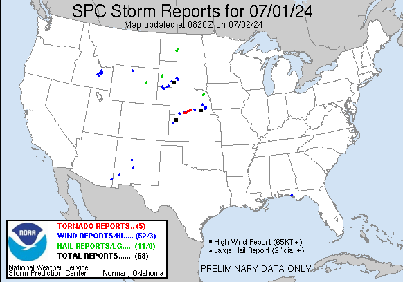