| Note: All Reports Are Considered Preliminary |
|
|
|
|
| Tornado Reports (CSV) (Raw Tornado CSV)(?) |
|---|
| No reports received |
| Hail Reports (CSV) (Raw Hail CSV)(?) |
|---|
| No reports received |
| Wind Reports (CSV) (Raw Wind CSV)(?) |
|---|
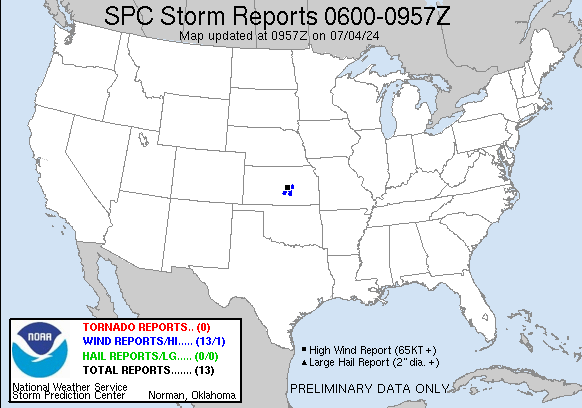
Time | Speed | Location | County | State | Lat | Lon | Comments |
| 0600 | 59 | 1 NE Inman | McPherson | KS | 3823 | 9777 | (ICT) |
| 0604 | 58 | 1 W Canton | McPherson | KS | 3838 | 9744 | (ICT) |
| 0605 | 76 | 1 S Mcpherson | McPherson | KS | 3836 | 9766 | (ICT) |
| 0609 | 67 | 5 ESE Partridge | Reno | KS | 3793 | 9802 | (ICT) |
| 0609 | 58 | 6 N Moundridge | McPherson | KS | 3829 | 9751 | (ICT) |
| 0609 | 72 | 1 W Canton | McPherson | KS | 3838 | 9744 | (ICT) |
| 0613 | 63 | 4 S Durham | Marion | KS | 3843 | 9723 | (ICT) |
| 0615 | 58 | 3 E Hutchinson | Reno | KS | 3807 | 9786 | (ICT) |
| 0625 | 59 | 1 SW Hillsboro | Marion | KS | 3834 | 9721 | (ICT) |
| 0642 | UNK | 2 WNW Newton (GL | ) | | | | |
| 0642 | UNK | 2 WNW Newton | Harvey | KS | 3805 | 9737 | Large tree uprooted. (ICT) |
| 0659 | 60 | Sedgwick | Harvey | KS | 3792 | 9742 | (ICT) |
| 0700 | 59 | 2 NE Maize | Sedgwick | KS | 3779 | 9743 | (ICT) |
|

| Filtered Tornado Reports (CSV) (Raw Tornado CSV)(?) |
|---|
| No reports received |
| Filtered Hail Reports (CSV) (Raw Hail CSV)(?) |
|---|
| No reports received |
| Filtered Wind Reports (CSV) (Raw Wind CSV)(?) |
|---|
Time | Speed | Location | County | State | Lat | Lon | Comments |
| 0605 | 76 | 1 S Mcpherson | McPherson | KS | 3836 | 9766 | (ICT) |
| 0609 | 67 | 5 ESE Partridge | Reno | KS | 3793 | 9802 | (ICT) |
| 0609 | 72 | 1 W Canton | McPherson | KS | 3838 | 9744 | (ICT) |
| 0613 | 63 | 4 S Durham | Marion | KS | 3843 | 9723 | (ICT) |
| 0615 | 58 | 3 E Hutchinson | Reno | KS | 3807 | 9786 | (ICT) |
| 0642 | UNK | 2 WNW Newton | Harvey | KS | 3805 | 9737 | Large tree uprooted. (ICT) |
| 0659 | 60 | Sedgwick | Harvey | KS | 3792 | 9742 | (ICT) |
| 0700 | 59 | 2 NE Maize | Sedgwick | KS | 3779 | 9743 | (ICT) |
|
| The Storm Reports page is organized based on reports received from 1200 UTC to 1159 UTC the next day. For example, storm report page for 20150430 covers reports from 20150430 at 1200 UTC to 20150501 at 1159 UTC. |
| Full report in comma-separated values (CSV) format and in KML format. |
| Full filtered report in comma-separated values (CSV) format and in KML format. |
| KML files are created with time-enabled placemarks compatible with Google Earth Time Slider. |
| Raw full report in comma-separated values (CSV) format. |
| Fields marked UNK are unknown. |
| All Times UTC. |
| Wind Gusts in MPH. |
| Hail Sizes in 1/100 of an Inch (175 = 1.75") |
| LAT/LON in decimal degrees to two decimals, see SPC FAQ for more info. |
| List of Weather Forecast Office 3-letter IDs appear in the report comments section. |
|
|
|
Top/Storm Reports/Home
|


 @NWSSPC