SPC AC 040553
Day 1 Convective Outlook
NWS Storm Prediction Center Norman OK
1253 AM CDT Thu Jul 04 2024
Valid 041200Z - 051200Z
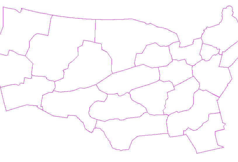
...THERE IS A SLIGHT RISK OF SEVERE THUNDERSTORMS ACROSS THE UPPER
MISSISSIPPI VALLEY AND FROM THE MISSOURI OZARKS INTO THE SOUTHERN
PLAINS...
...SUMMARY...
Severe thunderstorms will be possible across parts of the Upper
Mississippi Valley, Ozarks, and southern Plains.
...Discussion...
Seasonally strong upper trough is shifting east across the northern
Plains early this morning. This feature is forecast to advance
toward the middle MO Valley by late afternoon as 500mb, 60kt speed
max translates across southeast NE into IA. Left exit region of this
speed max will spread across the upper MS Valley along with a
corridor of modest 12hr mid-level height falls. Latest model
guidance suggests a weak surface low will develop and track along
the MN/IA border into southwest WI by late evening. This corridor
appears favorable for robust convective development as boundary
layer warms and convective temperatures are breached, likely by
midday, as readings warm through the upper 70s-80F. Forecast
soundings exhibit veering wind profiles with height, and some
supercell potential exists within this zone of focused ascent. Large
hail and locally damaging winds are the primary concerns.
Farther south, an expansive corridor of convection has evolved over
the central Plains early this morning. Upscale growth may continue
for the next few hours, and a long-lived MCS should propagate across
eastern KS into MO by sunrise. While this complex may not be
particularly severe at daybreak, a long-lived MCS, or its remnants,
will advance downstream into the OH Valley as modest mid-level flow
will extend along a corridor from MO into southern OH. Models are
not too aggressive in steepening low-level lapse rates east of the
MS River later today, but some surface heating is expected to
contribute to increased buoyancy that will likely contribute to new
robust updrafts developing along the MCS outflow/differential-
heating zone. Will maintain MRGL risk across this region, although
somewhat higher severe probabilities may be warranted, especially
across KY along the southern flank of the forward-propagating MCS.
Later in the day, very strong surface heating across the southern
Plains will result in steep surface-3km lapse rates from northwest
TX, across central into northeast OK. As the northern Plains trough
shifts east, mid-level flow will begin to turn more westerly across
northern OK, and 500mb speeds will increase to 25-40kt north of
I-40. Convective temperatures will be breached by 22z, just ahead of
the surface front, and scattered thunderstorms should easily develop
along the wind shift. PWs will be very high across this region with
values in excess of 2 inches. With temp/dew point spreads around
30F, there is increasing confidence that the most robust convection
should generate severe downdrafts. A fairly concentrated corridor of
convection should evolve downstream into the MO Ozarks by early
evening.
..Darrow/Squitieri.. 07/04/2024
CLICK TO GET WUUS01 PTSDY1 PRODUCT
NOTE: THE NEXT DAY 1 OUTLOOK IS SCHEDULED BY 1300Z
|


 @NWSSPC